Best Spots for Solitude in Great Smoky Mountains National Park: The 2025 Quiet Explorer’s Guide
- Why Finding Solitude in the Smokies Matters More Than Ever
- Start with the Time of Day: Early Mornings or Late Afternoons
- Middle Prong Trail: A Hidden Waterfall Wonderland Without the Crowds
- Big Creek Trail to Mouse Creek Falls: Serenity Along a Mountain Stream
- Boogerman Trail: Ghost Town Silence in Cataloochee Valley
- Spruce Flat Falls Trail: Short, Steep, and Surprisingly Quiet
- Deep Creek Loop: Waterfalls Without the Bus Tours
- Quiet Trails at a Glance – Difficulty, Distance & Solitude Factor
- Ramsey Cascades Trail: Earn Your Silence on a Tough Climb
- Thomas Divide Trail: Ridge Views Without the Clingmans Crowds
- Bote Mountain Trail: Off-the-Radar Wilderness Near the Spines
- Low Gap Trail to Mount Cammerer: Long, Quiet, and Worth the Effort
- Twentymile Trail: A Remote Escape Few Ever Hike
- Cove Mountain Trail: The Secret Side of Gatlinburg
- Gabes Mountain Trail to Hen Wallow Falls: Waterfall Without the Rush
- Forney Ridge Trail: Escape Clingmans Dome, Find Peace on Andrews Bald
- FAQ

Why Finding Solitude in the Smokies Matters More Than Ever
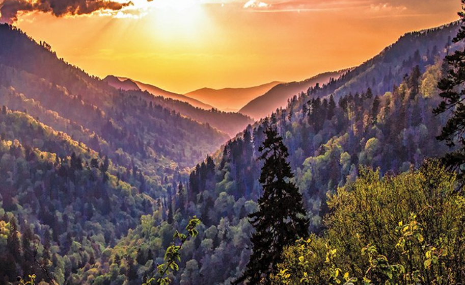
The Great Smoky Mountains are America’s most-visited national park, drawing over 12 million visitors annually. And while the crowds cluster around iconic areas like Clingmans Dome and Cades Cove, the truth is: there’s still vast, peaceful wilderness out there—you just have to know where to look. I’ve hiked dozens of trails here over the years, and I’ve found that the most moving experiences come not from snapping a photo at an overlook, but from standing alone in a misty forest where silence wraps around you like a blanket. This guide is for those seeking real solitude, whether for photography, personal reflection, or just an escape from the noise.
Start with the Time of Day: Early Mornings or Late Afternoons
Before we dive into the hidden gems, let’s talk timing. Even the quietest trails in the Smokies get foot traffic by midday. From experience, the hours just after sunrise and before sunset offer the best shot at silence. Mornings are especially peaceful—mist lingers over valleys, bird calls echo through empty hollows, and you’ll often have entire sections of trail to yourself.
Late afternoons are also good, though you may run into returning hikers. As with sunset hikes like how to hike to delicate arch at sunset, the golden hour brings a special kind of calm to the forest that’s worth chasing—just plan for daylight on the way back.
Middle Prong Trail: A Hidden Waterfall Wonderland Without the Crowds
Tucked away in the Tremont area, Middle Prong Trail is a true gem for solitude-seekers. While nearby Laurel Falls is packed with visitors, this 8.3-mile round-trip hike offers roaring cascades, mossy bridges, and almost no one else on the trail—especially during shoulder seasons.
The trail follows an old railroad grade, making it wide and gentle despite the mileage. Waterfalls appear every few minutes, and the forest is lush year-round. The further you go, the quieter it gets. It’s perfect for a meditative solo hike or a peaceful couple’s walk, with plenty of spots to stop and soak it all in.
Big Creek Trail to Mouse Creek Falls: Serenity Along a Mountain Stream
On the eastern edge of the park near the North Carolina side, Big Creek Trail offers a shady, quiet route along crystal-clear water. It’s a moderate 4-mile round trip to Mouse Creek Falls, but many people only go halfway—meaning you’ll likely have the falls to yourself if you linger.
The trail was once a railroad path, so it’s smooth, wide, and ideal for beginners, but don’t let the ease fool you—it’s packed with natural beauty and far from the crowds. Even in summer, it stays cool under tree cover. For RV travelers coming from I-40, this is one of the easiest solitude spots to reach, and a perfect contrast to the congestion found around Elkmont or Sugarlands.
Boogerman Trail: Ghost Town Silence in Cataloochee Valley
Cataloochee is one of the most remote regions of the Smokies, and that’s exactly why solitude-seekers love it. The Boogerman Trail, a 7.4-mile loop through old-growth forest and historic homesteads, offers a unique kind of quiet: not just natural stillness, but the haunting silence of abandoned farmsteads and decaying log cabins.
Most tourists never make it out here due to the rough access road, but if you do, you’ll be rewarded with towering hemlocks, clear creeks, and maybe even a bugling elk in the distance. Bring plenty of water and prepare for some moderate elevation changes—it’s not an easy stroll, but the isolation is worth every step.
Spruce Flat Falls Trail: Short, Steep, and Surprisingly Quiet
Near the Tremont Institute, Spruce Flat Falls Trail is a lesser-known gem that packs beauty into just 2 miles round trip. Despite being relatively close to the popular Cades Cove area, the trail sees very little foot traffic.
It climbs steadily through shaded forest before revealing a beautiful tiered waterfall that feels like it belongs in a secret garden. I’ve visited multiple times and shared the space with only the sound of water. Early mornings here are especially rewarding, and it’s one of the rare spots where you can enjoy a waterfall and not have to elbow for photo space.
Deep Creek Loop: Waterfalls Without the Bus Tours
If you’re looking for a blend of accessible hiking and real peace, Deep Creek Loop near Bryson City is ideal. The loop can be customized to be as short as 2.4 miles or stretched to 5+ miles, depending on your route. You’ll pass three waterfalls—Tom Branch, Indian Creek, and Juney Whank—with very few people on the trail past the first mile.
Most visitors stick to the picnic areas, so once you move beyond the bridge near the parking lot, the crowds fade fast. I often recommend this to friends traveling through the Smokies from national parks out west, where reservation systems are becoming the norm.

Quiet Trails at a Glance – Difficulty, Distance & Solitude Factor
| Trail Name | Distance (Round Trip) | Difficulty | Notable Feature | Solitude Level |
| Middle Prong Trail | 8.3 miles | Moderate | Multiple waterfalls, mossy path | Very High |
| Big Creek Trail | 4 miles | Easy | Mountain stream, waterfall | High |
| Boogerman Trail | 7.4 miles | Moderate | Ghost town ruins, old forest | Very High |
| Spruce Flat Falls | 2 miles | Moderate | Tiered waterfall, shady forest | Moderate to High |
| Deep Creek Loop | 2.4–5 miles | Easy | Three waterfalls, creek sounds | Moderate to High |
Ramsey Cascades Trail: Earn Your Silence on a Tough Climb
At 8 miles round-trip with over 2,000 feet of elevation gain, the Ramsey Cascades Trail isn’t for the faint of heart—but that’s precisely what keeps it blissfully quiet. Located in the Greenbrier area, this trail winds through some of the park’s most impressive old-growth forests, leading to a stunning 100-foot cascade that feels like nature’s cathedral.
Because of the difficulty, the trail sees far fewer hikers than other waterfall routes. If you leave early (before 8 AM), chances are you’ll have much of the path to yourself until your return. Just wear good boots—the trail can be rocky and slippery in spots—and bring more water than you think you’ll need.
Thomas Divide Trail: Ridge Views Without the Clingmans Crowds
Looking for panoramic mountain views without a tour bus in sight? Skip the Clingmans Dome throngs and try the Thomas Divide Trail, which offers quiet ridge hiking and long sightlines with very little foot traffic. This trail connects with other longer backcountry routes, making it a favorite among solo backpackers and thru-hikers.
It’s not a loop, so you’ll need to plan your turnaround point, but even a 3- to 4-mile out-and-back hike from the trailhead offers immersive forest and unexpected views across multiple ridges. Deer and wild turkeys are common here, and in spring, the wildflowers put on a show.
Bote Mountain Trail: Off-the-Radar Wilderness Near the Spines
While not as flashy as Alum Cave or Chimney Tops, Bote Mountain Trail is a solid solitude pick that intersects with the Appalachian Trail but starts from a much quieter access point. The climb is steady and moderately steep, but it opens to ridgelines and quiet forest plateaus that feel like they’re a world away from the main roads.
I recommend this trail for those who enjoy longer, meditative hikes. It’s a good introduction to the less-trafficked western Smokies, and it’s rarely busy—even in summer. You won’t find waterfalls or rock arches here—just deep woods, breathing space, and stillness.
Low Gap Trail to Mount Cammerer: Long, Quiet, and Worth the Effort
This hike is not for the casual stroller—it’s for those who want to earn their solitude. The Low Gap Trail to Mount Cammerer is an 11-mile round trip that begins in the Cosby Campground area and climbs steadily up through hardwood forest before reaching a narrow ridge that opens to stunning mountain views. The final push is a spur trail that snakes around exposed rock to reach the historic Mount Cammerer fire tower—a stone-built lookout that sits on a high bluff with panoramic views of the Pigeon River Gorge.
Few people attempt this hike in a single day, and many who do end up turning back before the summit. That’s what makes it so peaceful. If you’re fit enough to go the distance, you’re rewarded with silence and one of the best vantage points in the eastern Smokies. I remember sitting at the top, legs over the edge, listening only to the wind and distant birdsong. No cell signal. No voices. Just the sound of being completely untethered from the world below.
If you’re into photography, bring a lightweight tripod—sunrise and late afternoon light here is golden. And don’t forget: the fire tower is accessible year-round, but ice and leaf-covered rocks can make the upper switchbacks treacherous in winter and fall. Wear grippy footwear, carry 2–3 liters of water, and plan for a full 6–8 hour adventure.
Twentymile Trail: A Remote Escape Few Ever Hike
If there’s one place in the Smokies where you can feel like the entire forest belongs to you, it’s Twentymile Trail. Located near Fontana Dam at the park’s far southwestern edge, this area gets a fraction of the visitors that flood Gatlinburg or Clingmans Dome. You’ll need to drive several twisty miles to reach the trailhead—but that effort pays off in complete stillness.
The trail follows an old logging road for several miles, hugging Twentymile Creek as it climbs gently through dense hardwood forest, over log bridges and past quiet pools. It’s the kind of path where you’ll notice the subtle things—lichens glowing on rocks, moss growing on bark, footprints of wild turkey and deer.
Twentymile is also a gateway trail. It links with Gregory Bald Trail, Appalachian Trail, and several backcountry campsites, making it a key part of multi-day loops. But even as a short out-and-back walk (4–6 miles), it delivers that rare wilderness feeling. If you’re a landscape painter, poet, or someone simply trying to reset mentally, this trail clears your head like nothing else.
Bring bear spray and be prepared to navigate using a paper map or GPS app like Gaia—this part of the park is not well-marked, and that’s part of its charm.
Cove Mountain Trail: The Secret Side of Gatlinburg
It’s hard to imagine that just minutes from bustling Gatlinburg, with its neon signs and pancake houses, there’s a trail that offers real silence—but Cove Mountain Trail proves it. Starting near the Sugarlands Visitor Center, this 8.5-mile (one way) hike is a gradual climb that sheds people almost immediately after the first bend.
The first few miles are shaded, quiet, and filled with bird calls. As you climb, the trees begin to thin slightly, offering occasional peeks of the surrounding ridgelines. There’s no single “wow” moment, but the magic of this trail lies in the buildup of calm—the way the noise of the world disappears with each step.
Many hikers use this trail to reach Laurel Falls from the back way, but if you’re only interested in solitude, you can simply do a 4–6 mile out-and-back and turn around before the falls. I like to stop at a flat mossy spot around mile 3, where the canopy opens up just enough for a thermos of coffee and a sketchbook.
Because it’s so close to town, Cove Mountain is a perfect option for travelers staying in Gatlinburg who want solitude without driving deep into the park.
Gabes Mountain Trail to Hen Wallow Falls: Waterfall Without the Rush
Tucked away in Cosby, one of the most under-appreciated corners of the park, Gabes Mountain Trail is a 4.4-mile round-trip route that leads to Hen Wallow Falls—a narrow, graceful 90-foot drop that spills like a ribbon down a mossy rock face.
This hike is perfect for those who want a waterfall experience without the crowds. The trail starts right behind Cosby Campground and meanders gently through a rhododendron forest, filled with ferns, fungi, and the gentle rush of nearby water. There are short wooden footbridges and pockets of silence where it feels like time slows down.
The trail isn’t difficult but has enough roots and rocks to keep it interesting. And unlike Laurel Falls or Grotto Falls, there’s rarely more than a few people at Hen Wallow—especially before 10 AM or in cooler months. It’s a wonderful choice for a romantic hike, reflective solo time, or quiet nature photography.
There’s a small spur trail near the falls that leads to a better angle—be careful here, especially after rain, as the rocks can be slick. I always bring trekking poles for balance and a towel if I plan to dip my feet in the pool at the base.
Forney Ridge Trail: Escape Clingmans Dome, Find Peace on Andrews Bald
Clingmans Dome may be the busiest place in the Smokies—but few visitors realize that just beyond the observation tower parking lot lies a trail to real peace. Forney Ridge Trail begins at the same parking area but quickly diverges into a quieter, older forest. Within five minutes, you’re in a different world—high-elevation spruce-fir woodland, rich with scent, fog, and quiet.
The trail leads to Andrews Bald, a grassy open meadow with wildflowers in late spring and summer. At 3.5 miles round trip, it’s manageable for most fitness levels, though the return climb can be a bit tiring. Still, the payoff is huge: sweeping views of the southern Smokies, and often not another soul in sight.
It’s a perfect example of how you can find solitude even near the busiest hotspots, just by taking a different path. Come early or late to avoid parking chaos, and wear layers—it can be 20 degrees cooler at this elevation than in the valleys.
FAQ
What’s the absolute quietest trail in the Great Smoky Mountains?
While “quietest” can vary by season and time of day, Twentymile Trail is consistently among the most remote. Its distance from main entrances and lack of major landmarks keep crowds away. On weekdays, you can hike for hours here and not see another person, especially deeper into the backcountry.
Are there any solitude-friendly hikes near Gatlinburg?
Yes—surprisingly. Cove Mountain Trail begins right near the busy Sugarlands Visitor Center but quickly climbs into silence. Once past the first mile, the crowds thin dramatically. It’s a great option for solitude without a long drive into the backcountry.
When is the best time of year to avoid crowds in the Smokies?
Late winter to early spring (February–April) and late fall (after mid-October) are the quietest seasons. Trails are cooler, wildlife is more active, and parking lots are half empty. Just avoid holiday weekends and leaf-peeping peak days in October if possible.
Is early morning really the best time for solitude?
Absolutely. Hitting the trail before 8 AM guarantees you’ll beat 90% of the foot traffic. Even popular trails like Deep Creek or Ramsey Cascades can feel peaceful if you’re one of the first out. Plus, the light is better for photos and wildlife spotting.
Are there any solitude spots accessible to beginner hikers?
Yes—trails like Big Creek Trail, Deep Creek Loop, and Spruce Flat Falls offer relatively easy terrain with quiet pockets, especially beyond the first mile. These are great for casual hikers looking to avoid the crowds without committing to strenuous elevation.
Can I camp in solitude in the Smokies?
Yes, especially if you reserve one of the backcountry campsites accessible from remote trails like Boogerman or Twentymile. You’ll need a backcountry permit, but many sites are one-party-only, giving you a peaceful night under the stars with no neighbors in sight.
Is there cell service on the quietest trails?
Yosemite and Glacier both have permit systems and crowd control measures now. In Glacier, for instance, access to certain areas is limited without a reservation. The Smokies are open and free to enter year-round—but that also means more people. That’s why knowing these hidden trails is so valuable.
Is it safe to hike these remote trails solo?
Yes—with preparation. Bring water, a headlamp, downloaded maps, and a basic first aid kit. Always sign in at trailhead registries when available, and let someone know your plans. I’ve done many solo hikes here and never had an issue—but I always plan ahead.
Can I combine solitude hikes with RV camping nearby?
Definitely. There are multiple RV-friendly campgrounds and national forest boondocking sites near the Smokies. While you can’t camp just anywhere, planning RV stays near towns like Cosby or Bryson City gives you quick access to remote trailheads.
Are there waterfalls I can visit without big crowds?
Yes—Middle Prong, Hen Wallow, and Mouse Creek Falls are all scenic, accessible by foot, and far less trafficked than Abrams or Laurel Falls. These give you that waterfall experience without the busloads of tourists.
Do I need permits for any of these hikes?
Not for day hikes. However, backcountry camping does require a permit, which you can obtain online through the NPS Smokies site. There are no entrance fees to the park, but always check trail conditions before long hikes, especially after storms.
Are there solitude trails with scenic views, not just forest?
Yes! Thomas Divide, Mount Cammerer, and Forney Ridge to Andrews Bald all reward hikers with expansive mountain vistas. They offer both silence and sweeping Smoky Mountain scenery—without the chaos of Clingmans Dome or Newfound Gap.

Post Comment