How Long Does It Take to Drive the Entire Blue Ridge Parkway?
- Total Length and Route of the Parkway
- Estimated Driving Time Without Stops
- Factors That Influence Your Drive Time
- Sample Drive Times by Segment
- Best Time of Year to Drive the Blue Ridge Parkway
- Ideal Itineraries: One Day vs. Multi-Day Drives
- Top Stops Along the Parkway That Will Extend Your Drive
- Driving Tips for First-Timers
- Planning Fuel Stops Along the Parkway
- Is It Better to Drive North to South or South to North?
- Connecting the Parkway to Other Scenic Routes
- Final Thoughts on How Long It Really Takes
- FAQ
Total Length and Route of the Parkway
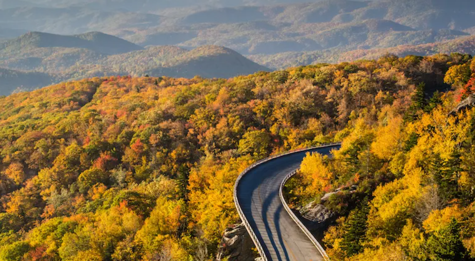
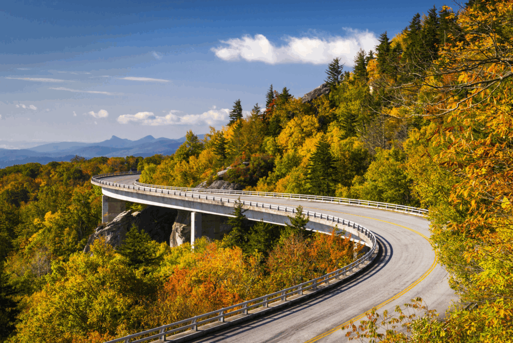
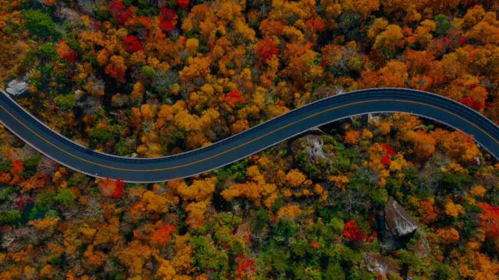
The Blue Ridge Parkway stretches 469 miles through two states: Virginia and North Carolina. It begins at Rockfish Gap, just outside of Shenandoah National Park, and ends near Cherokee, North Carolina, at the entrance to the Great Smoky Mountains National Park. The route is uninterrupted by commercial development, so you won’t see fast food chains or gas stations directly on the road. That’s part of what makes it magical—and part of what requires careful planning.
Driving it feels more like traveling back in time, winding past mountain farms, ridges, valleys, and forests that are protected from modern sprawl. Because it’s a scenic byway, not a highway, the speed limit rarely exceeds 45 mph—and often dips to 25–35 mph in tighter curves, tunnels, or more elevated stretches.
Estimated Driving Time Without Stops
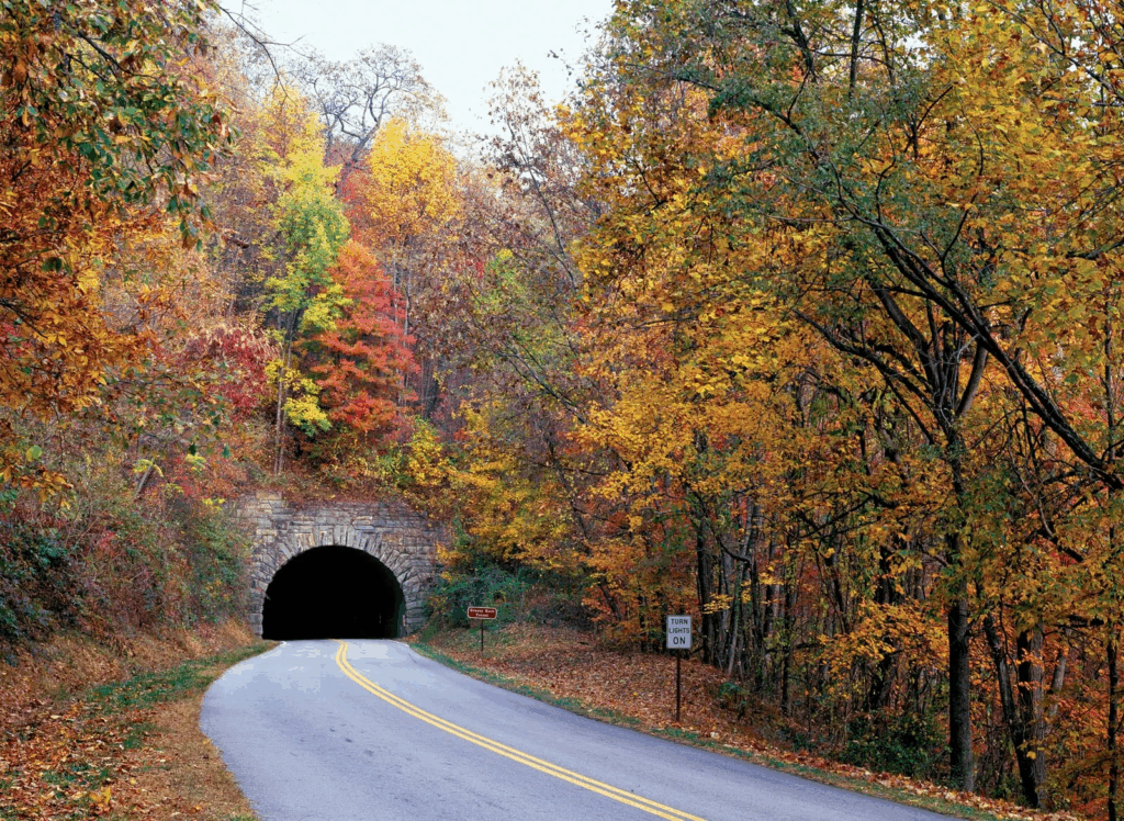
If you drive the entire Parkway without stopping, expect the trip to take around 12 to 14 hours. But here’s the catch: almost no one drives the Blue Ridge Parkway without stopping. And frankly, you shouldn’t. The road is intentionally designed for slow travel—there are over 200 scenic overlooks, 26 tunnels, and dozens of potential detours to charming towns, hiking trails, waterfalls, and cultural sites.
You can technically complete the route in a single day if you’re determined, but it would be a physically draining and visually overwhelming experience. Most travelers break it up over 2–5 days depending on how many attractions they want to see and how leisurely they want the pace to be. If you’re aiming to actually enjoy the Parkway—take pictures, walk trails, have a meal—you’ll need more than just a day.
Factors That Influence Your Drive Time
There are several elements that affect how long it will take you to drive the Blue Ridge Parkway:
- Speed limits: The entire route is governed by low speed limits—typically 35 to 45 mph. That alone adds hours compared to a typical highway trip.
- Seasonal traffic: Fall foliage season (late September to early November) and weekends in summer can lead to slower traffic and congestion, especially near popular viewpoints.
- Weather: Fog, rain, or ice can be frequent in certain elevations and seasons. Visibility issues can force you to slow down dramatically, and parts of the road may close temporarily in winter.
- Road work or closures: Some segments may be under maintenance or closed due to landslides or weather damage. Detours can significantly alter your schedule.
- Your own itinerary: Planning to stop for hikes, photos, or meals? Those pauses add up—and they should! It’s all part of the experience.
If you’re traveling in an RV or towing a camper, expect your pace to be even slower, especially on curvy stretches or in elevation changes.
Sample Drive Times by Segment
| Segment | Distance | Average Drive Time (No Stops) | Notes |
| Rockfish Gap (VA) to Roanoke (VA) | 120 miles | ~3.5 hours | Scenic overlooks and historic sites |
| Roanoke (VA) to Fancy Gap (VA/NC border) | 80 miles | ~2.5 hours | Lots of elevation change |
| Fancy Gap to Blowing Rock (NC) | 100 miles | ~3 hours | Popular with fall leaf peepers |
| Blowing Rock to Asheville (NC) | 90 miles | ~3 hours | Waterfalls, tunnels, and hikes |
| Asheville to Cherokee (NC) | 79 miles | ~2.5 hours | Highest elevation and sweeping views |
| Entire Parkway | 469 miles | 12–14 hours | Without breaks or detours |
This breakdown shows that even if you’re keeping a steady pace, this is a drive that spans the better part of a full day. But again, if you’re doing it right, it’ll take you longer—in the best way possible.
Best Time of Year to Drive the Blue Ridge Parkway
Timing is everything on the Parkway. While the road is technically open year-round (weather permitting), some months are significantly more rewarding—and safer—than others. The most popular time to drive is during autumn, especially from late September to early November, when fall foliage transforms the mountains into waves of red, gold, and orange. It’s a bucket-list experience, but also the busiest time, especially around hubs like Blowing Rock and Asheville.
Spring (April–May) brings wildflowers, dogwoods, and rhododendrons blooming along the shoulders of the road. The weather is milder and the crowds are thinner than in fall. Summer (June–August) is lush and vibrant, perfect for camping or family trips, but can be crowded and occasionally foggy in higher elevations. Winter (December–March) can be serene, but snow and ice often shut down sections—especially near Mount Pisgah and Craggy Gardens.
So if you’re asking not just how long, but when to drive the Parkway, consider this: late spring and early fall offer the best balance between beauty and manageability.
Ideal Itineraries: One Day vs. Multi-Day Drives
If you only have one day, focus on a manageable segment like Asheville to Cherokee or Roanoke to Blowing Rock. These are packed with views, short hikes, and visitor centers. You can still enjoy the essence of the Parkway in a single day, especially if you start early and plan your stops.
A two-day itinerary could cover the Parkway in halves: Day 1 from Rockfish Gap to Blowing Rock, and Day 2 from Blowing Rock to Cherokee. This gives you time for scenic detours, meal breaks, and a few short trails.
A three- to five-day trip is ideal. You can drive fewer miles per day, stay overnight in charming towns like Floyd, Boone, or Little Switzerland, and really engage with the landscape. You’ll have time for hikes to waterfalls, winery stops, music jams, and even some off-parkway adventures like Luray Caverns or the Biltmore Estate.
The more days you can stretch it, the less it becomes about the driving—and more about the journey.
Top Stops Along the Parkway That Will Extend Your Drive
Let’s be real: you’re going to want to stop. Here are a few iconic stops that could add hours—but also incredible memories:
- Mabry Mill (Milepost 176.1): One of the most photographed spots on the Parkway. Demonstrations of old-time crafts and fresh cornmeal pancakes.
- Peaks of Otter (Milepost 86): Lakeside views and access to hiking trails like Sharp Top Mountain.
- Linville Falls (Milepost 316): A short hike leads to multiple waterfall viewpoints.
- Craggy Gardens (Milepost 364): Rhododendrons in bloom in early summer; dramatic ridge views.
- Mount Mitchell (Milepost 355.4): The highest point east of the Mississippi—accessible by car.
- Blue Ridge Music Center (Milepost 213): Live Appalachian music performances in summer.
Each of these adds 30 minutes to a few hours depending on your pace, and that’s not even including meals, gas, or spontaneous photo stops. The Parkway isn’t built for speed—it’s built for lingering.
Driving Tips for First-Timers
If you’ve never driven the Parkway, there are some quirks you should know about:
- No gas stations on the Parkway. Plan fuel stops in advance. Exits are well marked, but towns can be miles off-route.
- No cell signal in many stretches. Download offline maps and print your itinerary just in case.
- Pack snacks and water. While there are some dining options near visitor centers or towns, they aren’t frequent.
- Watch for wildlife. Deer, turkeys, and even black bears cross the road, especially at dawn or dusk.
- Tunnel driving can be intimidating. Especially if you’re in a tall vehicle like an RV. Always check height clearance (most are 11–13 ft).
- Obey speed limits. Not just for safety, but because it’s part of the experience. This isn’t a race—it’s a scenic cruise.
The Parkway rewards patience, awareness, and a sense of wonder. It’s not about how fast you get there, but how fully you take it all in.
Planning Fuel Stops Along the Parkway
One of the most important things to prepare for when driving the Blue Ridge Parkway is fuel. Since there are no gas stations directly on the route, you need to plan your refueling points carefully. The Parkway crosses or runs near several small towns and highways, and many of these offer easy access to fuel—though some require a 10–15 minute detour.
Locations like Waynesboro, Roanoke, Boone, Asheville, and Cherokee are reliable spots to fill up. Between those larger towns, there are smaller communities like Meadows of Dan or Little Switzerland, which offer limited services. A full tank at the start of your drive can often last through a full day’s travel if you’re not detouring much, but the mountain driving does use more fuel than flat terrain. Altitude, frequent braking, and curvy roads can all impact gas mileage.
Make a habit of refueling whenever you’re below half a tank and see a nearby opportunity. The Parkway isn’t the kind of place where you want to be anxiously watching the fuel gauge while climbing a ridge or coasting past a foggy overlook.
Is It Better to Drive North to South or South to North?
This is a question I get asked all the time, and the truth is: you can’t go wrong. Driving from north to south, starting in Virginia and ending in North Carolina, tends to offer a gradual build in elevation and landscape drama. You begin in rolling hills and end with dramatic views of the Smoky Mountains—saving the most intense scenery for last.
On the other hand, driving south to north has its own rewards. You kick off with the highest elevations and widest views around Asheville and Mount Mitchell, which can be breathtaking. From there, you slowly descend into softer landscapes and historic farmland. This direction also puts the sun mostly behind you during morning drives, reducing glare if you’re an early riser.
Ultimately, your choice may come down to logistics—where you’re starting, where you’re staying, or what fits your broader travel plans. But both directions offer more than enough beauty to make the decision feel secondary.
Connecting the Parkway to Other Scenic Routes
The Blue Ridge Parkway doesn’t exist in isolation—it’s part of a larger scenic corridor stretching from the Shenandoah Valley down through the Smoky Mountains and beyond. At its northern end, the Parkway connects seamlessly to Skyline Drive, the scenic route through Shenandoah National Park. If you’re coming from Washington D.C. or northern Virginia, this makes for a logical and beautiful entry point.
At the southern end, the Parkway flows directly into U.S. 441, which takes you into Great Smoky Mountains National Park. From there, many travelers continue into Tennessee, exploring towns like Gatlinburg or Pigeon Forge. Others head west into Cherokee heritage sites or south toward the waterfalls of western North Carolina.
For even more adventure, consider detours to Cherohala Skyway, Tail of the Dragon, or Pisgah Loop—each offering a wilder, more adrenaline-filled driving experience compared to the peaceful pace of the Parkway.
Final Thoughts on How Long It Really Takes
If you strip away all the stops, slowdowns, and surprises, the Parkway can technically be driven in a single day. But that approach misses the point entirely. The Blue Ridge Parkway is not just about miles and minutes. It’s about entering a different kind of space—one governed not by urgency, but by appreciation.
In my experience, the best drives are the ones where time loses its grip. You forget how long you’ve been on the road because your senses are fully engaged. Whether you give yourself two days or five, the true measure of the journey isn’t the clock—it’s the memories you take home.
So when someone asks, “how long does it take to drive the Blue Ridge Parkway?” I always answer: it depends how much beauty you’re willing to see.
FAQ
Can I drive the Blue Ridge Parkway in one day?
Yes, it’s technically possible to complete the entire 469-mile drive in a single day if you don’t make any stops. However, that kind of drive misses the entire point of the Parkway. It’s meant to be savored, not rushed. Most travelers find the most rewarding experience comes from spreading the drive over two or more days, allowing time for scenic overlooks, short hikes, meals, and exploration.
Is the Blue Ridge Parkway open year-round?
The Parkway is open year-round in theory, but in practice, certain sections often close due to weather conditions. In winter, snow and ice frequently shut down higher elevations, especially in North Carolina. Even during spring and fall, heavy rain or fallen trees can trigger temporary closures. Always check the official National Park Service alerts before you begin your trip.
What direction is best to drive the Parkway?
There’s no right or wrong direction. Driving from north to south (starting near Shenandoah) lets you ease into the mountain landscape, with the scenery growing more dramatic as you approach the Smoky Mountains. Driving from south to north offers higher elevations and more open views right from the start. Many travelers choose based on convenience or daylight patterns for photography.
Are there gas stations directly on the Parkway?
No, there are no gas stations located on the Parkway itself. You’ll need to exit the route and drive a few miles into nearby towns to refuel. It’s wise to keep your tank at least half full and plan stops in advance, especially in the more remote central sections of the route where services are scarce.
Can I bring pets on the Blue Ridge Parkway?
Yes, pets are allowed on the Parkway, but they must be kept on a leash at all times. Many overlooks and picnic areas are pet-friendly, and some trails allow leashed dogs as well. However, pets are not permitted inside Parkway buildings or visitor centers. Make sure to bring water and waste bags for your pet’s comfort and safety.
Is the Parkway safe to drive at night?
It’s technically safe but not ideal. The road is very dark, with no lighting, frequent curves, wildlife crossings, and limited visibility. Tunnels can be disorienting, and fog is common in higher areas. If you must drive at night, take it slow and remain alert. However, most travelers prefer to enjoy the Parkway during daylight hours when the views are at their best.
Can RVs and trailers drive the entire route?
RVs and trailers are allowed, but drivers should use caution. Some tunnels have height restrictions as low as 10 feet, and the road’s many sharp curves can be difficult for long vehicles. Before setting out, RV travelers should check a tunnel height chart and avoid sections that might pose clearance issues. The drive is possible, but slower and more complex for larger rigs.
Are there restaurants on the Parkway?
There are a few dining spots directly on or just off the Parkway, such as Pisgah Inn and Peaks of Otter Lodge. However, food options are generally limited along the route, especially in the more remote stretches. Most travelers pack snacks and stop in nearby towns for meals. Planning your food stops ahead of time can save stress and keep you well-fed throughout the journey.
How long does it take to drive just part of the Parkway?
If you want to experience only a portion of the Parkway, you can choose a segment that fits into a few hours. For example, the stretch from Asheville to Cherokee takes about 2.5 to 3 hours without stops. Roanoke to Blowing Rock is another popular partial route and can take 4 to 5 hours with scenic pauses. These shorter trips still offer rich scenery and are great for weekend escapes.
Is there cell phone service on the Parkway?
Cell phone coverage is spotty at best. In some higher elevations or near towns, you may get a signal, but much of the Parkway passes through remote wilderness with little or no reception. It’s highly recommended to download offline maps or bring printed directions and guidebooks. Don’t rely on GPS alone to navigate or find services.
Do I need to pay a fee to drive the Parkway?
No, the Blue Ridge Parkway is free to drive. There are no tolls, entrance fees, or parking charges at any of the overlooks or visitor centers. However, some nearby attractions off the Parkway—like state parks or private sites—may charge a fee. Camping in NPS campgrounds along the Parkway also requires a small fee or reservation.
Are there bathroom facilities along the route?
Yes, but not frequently. There are restrooms available at most visitor centers and some picnic areas, but they can be several miles apart. It’s a good idea to use the facilities whenever you see one, especially if you’re traveling with children or planning longer scenic detours. In remote areas, options are limited.
What’s the speed limit on the Parkway?
Speed limits vary depending on the section, but generally range from 35 to 45 miles per hour. In some curves, near tunnels, or high-traffic areas, the speed limit can drop to 25 mph. Driving too fast not only increases danger on winding roads but also risks missing the beauty around you. Law enforcement occasionally patrols, so it’s best to stick to posted limits.
Can I bike or motorcycle the Parkway?
Absolutely. Motorcyclists often love the Parkway for its smooth curves and lack of commercial traffic. Cyclists are also welcome, though the narrow lanes and elevation changes can be physically demanding. There are no dedicated bike lanes, so cyclists must ride in traffic and follow all road rules. It’s best for experienced riders or those with proper support vehicles.
Are there any shortcuts or detours I should know about?
If you’re running short on time, several U.S. highways and interstates cross the Parkway and can be used as detours or re-entry points. For example, I-81 in Virginia and I-40 in North Carolina can help bypass long stretches. However, these detours trade scenic beauty for speed. If you choose to exit early, plan it around meal stops, fuel needs, or weather concerns.

Post Comment